Riparian Health Part 3
by George Powell

In the previous two posts in this series on riparian health, I covered the importance of riparian systems to agriculture, and the need for measuring and monitoring their health.
In this post I’ll share some pro-tips on setting up and conducting an assessment. These include:
- Selecting an assessment area;
- Setting its boundaries;
- Assessent timing; and,
- Overcoming evaluation biases.
What Area to Monitor?
If your riparian area is relatively small, your assessment site can include all or the majority of the riparian zone. If, however, you have larger riparian areas, you will likely monitor a subset of that area. And, your selection choice comes down to using either a representative or a critical area.
Representative areas reflect the average conditions across all your riparian zones. Use them when you are primarily interested in comparing the ‘average’ health at one site to other farms or regions.
In contrast, critical areas reflect a particular management challenge or site condition. Used critical areas to track differences before and after management changes or restoration.
Riparian Boundaries
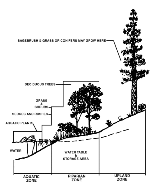
Defining where a riparian zone begins and ends can be a challenge. Nature doesn’t always provide us with sharp boundaries. And, a diversity of soil and aquatic conditions can make the transitions quite unclear.
The aquatic zone sets the lower or inner boundary of the riparian area. The upper or outer boundary is set by a change to terrestrial features. And this boundary is usually more difficult to locate. Indeed, it can be particularly challenging when the area has been highly modified by grazing or land clearing.
A primary visual cue to help you find the boundary is in the vegetation changes from water-loving to more drought-tolerant species. You can also look to topographic changes, such as terraces or embankments. And if the assessment is done early enough in the spring, look for clues left behind by the high water. These might include silt deposit on tree trunks. Sediments placed on top of ground vegetation will also show you where water has recently pooled. Or, you may be able to find debris that washed up in lines along the high water edge.
If all else fails, the flood-prone area can be used to set your riparian zone. First estimate the depth of the stream when it is at bank-full stage. Then, project a distance equal to twice that depth horizontally from the centre of the stream over the flood plain. This becomes your riparian zone for the purposes of the assessment.
When to Assess
Timing your assessment correctly is important. And consistency in any subsequent reassessments is very important. The best timing is when most plants are growing and can be identified. Stream or ground water conditions should also be close to normal. That is, not at or immediately after peak flood conditons.
When reassessing a site, match it to the same time period as the original assessment. And if management has significant, recurring impacts, make sure you factor them into your timing. For example, if your first assessment occured after a site was grazed by livestock, then follow up measures should also occur post-grazing.
Overcoming Biases
Visual assessments are susceptible to our cognitive biases. That is to say, how we perceive and process information when making a decision. Being self-aware of your evaluation biases will help you to overcome them.
Firstly, most of us carry a negativity bias. We place more emphasis on negative information than positive or neutral inputs. This can bias your visual assessments for elements such as the amount of bare ground or condition of trees and shrubs. Overcome this bias by keeping notes when walking through the entire length of the riparian area. Use a running tally of how much is altered vs intact. Small, highly disturbed areas are unsightly, but shouldn’t overwhelm the scoring of the site as a whole.
Visual assessments that require determining an average, are also susceptible to the recency effect. In essence, our brains place more weight on the last thing we observed. Again, notes are your friend to overcoming this bias. Walk the assessment site multiple times in different paths and directions. And review all the conditions you encounted before selecting a health score. This will help you mentally de-emphasize the serial-position effects.
Up Next
In the fourth segment on assessing riparian health, I’ll provide some tips and tricks on selecting the best answers for individual assessment questions.
Subscribe via RSS